

A Short History of South El Paso (1967)
Introduction:
There was once a culture of adobe structures and vineyards, and a society that existed in the north side of the river as well as the south. Yet this river that became an international boundary in 1848, split a unified community that had been existing in the area since at least 1683. Despite being clear on paper, the river was not able serve to provide a solid boundary between the Anglos and Latin Americans who existed in the same space, but separately. During the Civil War, there existed only about half a dozen English speaking families in El Paso.
From being only 7 square miles in 1902, the city had grown to 117 by the time of this publication (1967). The area defined by the riverbed along what is now Paisano has been known as South El Paso, or Chihuahuita because so many residents were from Chihuahua. It has also been referred to as the Chamizal, which until The Chamizal Convention of 1963 was still an area of a disputed border boundary. This report discusses the aims to develop the land and the south side, where primarily Mexicans lived. It is said a map was made in 1902 clearly showing this divide: The North part of second street (Paisano), and the south side.
Water and Geography
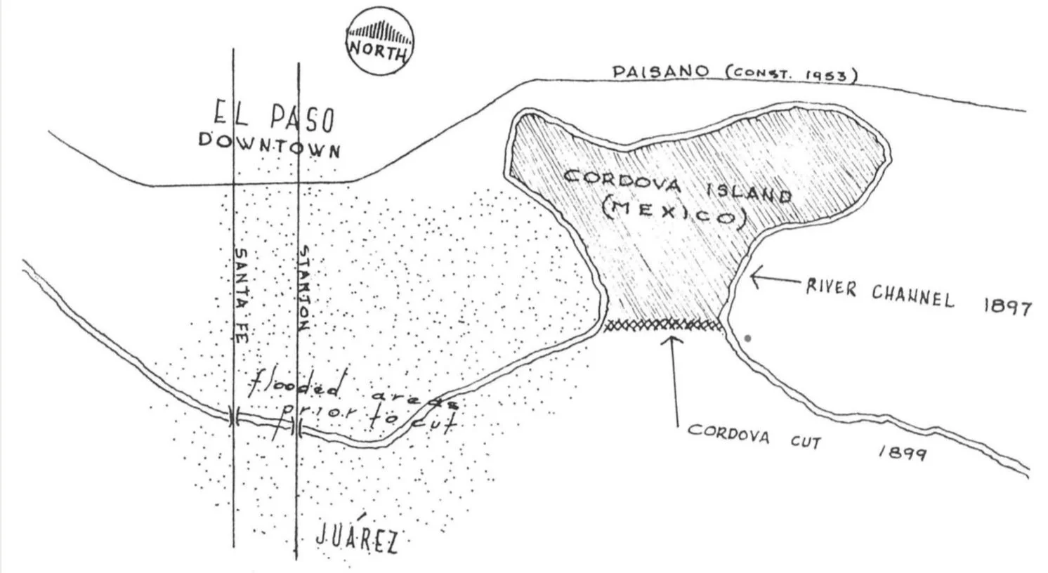
From floods to droughts, El Paso has had a history with water. With the environment ever changing from wet marshes to dry and sandy. In the past, two Mexican acequias carried irrigation water through the American side for many miles down the valley. These acequias connected to the river and wound around to manage water and provide irrigation, and an old Mexican dam diverted the water into these acequias which during dry times often held the only available running water. However, these and other minor ones were filled up by 1914. In subsequent years they had to continue be refilled to remain permanently removed. Floods were common, even filling up Oregon Street to San Jacinto Plaza with deep water. It was not until 1897 in lieu of another significant flood that a new channel for the Rio Grande was cut to reduce flood pressures.
Strongly impacting the south side, hundreds of Mexican and a number of American homes were destroyed by the flooding. It is said that Mayor Magoffin and the Mayor of Juarez joined forces to dig a new channel for the river water to flow. Known as the Cordova cut-off, the levees were finished in 1899 and the construction was officially ratified as a new channel in 1904 Cordova island was established. The Mexicans who had fled the flooding in 1897 were permitted by local attorney D. Storm to relocate on some land he owned in what became known as “Stormsville”.
While El Paso already had water and sewage systems in 1900s, they were still unsatisfactory and there was not equal access to the same level and quality of water and sewages systems. More details on the situation can be read in the PDF.
In 1881, the El Paso Water Company was franchised. In 1892, a new water treatment plant was built at the edge of the river near the old one, but river sediment would be pumped up along with the water. This made the sale of distilled drinking water from Deming and mountain towns a thriving business. Those who could afford it bought this drinking water. But production and distribution was expensive, and as the population grew so did local dissatisfaction. In 1902, El Paso was the second city in the U.S. to have a full metered public water supply. A set amount was provided at a set minimum monthly charge, and for every additional thousand gallons used twenty cents was charged. The first sewer line was laid in 1887. Improvements and expansions were made in phases through 1889, 1900, 1914 and so on.
Developed in the 1880’s with the purpose of providing irrigation to farmers, the Franklin Canal was never as profitable as those who constructed it had hoped it would become. Chartered in 1889 The El Paso Irrigation Company that constructed the canal was sold to an individual from Colorado. However, due to a dry spell the company was sold to El Paso Valley Water Users in 1909 who later sold it to the Federal government. For a time it became part of the Bureau of Reclamation’s Rio Grande Project, and provided water and sewer services. However, the years of private operation did little good for anyone, and water from the Mexican dam either came in and occasional flood or not at all, with a health officer in 1931 demanding it be covered up.
Transportation and Streets
The Railroad and Connections to Mexico
In 1881, the City of El Paso issued franchises for twelve railroads between the years 1880 and 1900. The original depot was built in 1881, but was retired in 1916 because of an old city agreement (5). In 1902 a brick depot was constructed at the west end of San Francisco street. While other bridges already existed, the first permanent bridge for the Mexican Central Railroad was built in 1881 by Zach White at El Paso Street, the second in 1882 on Stanton street for the streetcar system (trolley) of which there were four “streetcar” companies. These connected the El Paso and Juarez sides. Trees and vegetation once covered the banks nearly hiding the bridge from view. By 1900 the lines were electrified and the era of horses and mules pulling the cars were no more.
The first attempt to build a free bridge was recorded in 1915. However, one of the very first connections between El Paso and Juarez was a hand-hauled ferry operated by the Acosta family of Juarez.
Pavement and Streets
By 1900 there were still no paved roads, and only dusty or muddy streets. But 1906, financed by property assessments, the streets of Central El Paso north of Overland were paved. Sidewalks were added in 1907 and 1908 and by 1916, El Paso was a leading American city in laying eight miles of pavement in a single year. However, the paving hardly extended into the south side area, with, for example, El Paso Street to the river not being paved until 1951. Additionally, old acequias the city had covered up in the past had to be filled and refilled. After WWII, paving streets became a prime focus and all streets and alleys were finished by 1956.
In 1915, street name signs were introduced. Additionally, a ban on “sidewalk merchants” was imposed. With Police Chief Don Johnson notifying all City Patrolmen to keep sidewalks clear of merchants and goods.
The Chinese Population in El Paso
With the arrival of the railroad, Chinese laborers were imported. Many Chinese were brought in for construction, and settled in El Paso when construction ended, though not particularly welcomed. The Mexican Revolution also drove Chinese up to Juarez and El Paso, manz asking for special permission out of fear of the Carranza forces. Laundromats were a common business for those who lived in El Paso.
By the time of the Mexican revolution the population significantly increased
1904 a Chinese Masonic temple was dedicated
Sam Hing was considered the most influential Chinese in El Paso
During this time period most were found to have almost exclusively South El Paso addresses, with a few exceptions. Eventually the Chinese population dispersed.
The Development of Education and Religious Institutions in El Paso
Education in El Paso has always had its issues and challenges. Religious institutions played a notable role in the provision of education and basic resources like food and clothes. Here you can see a short timeline of the development of education and schools in El Paso, with some additional information on the social impact.
1883 Central School
1885 Mexican Preparatory school: Later becoming known as Aoy School, it first opened as a private free school and was established by Olivas Villanueva- a Spaniard. By 1925 there were 1767 students enrolled.
1890 Franklin: This school held Texas’s first kindergarden, and prominent American, Mexican, and German families from Juarez sent their children here many of whom rode the street car to school. They paid a monthly tuition that increased for higher grade levels.
In the 1910s, schools were built and improved upon, serving more and more students. Civic minded women of the wealth aristocratic and class as well as refugees from Mexico helped feed students in Franklin. When the soldiers left the border, a wooden barracks building was set in the back of the lot for non-english speaking children of various ages.
Churches
In 1848, when there were only a few people in the downtown district of El Paso, so Catholics would go down to Juarez for Sunday Mass. Yet over time, religious institutions played quite the role in El Paso in the early 20th century. Several charity organizations and services were established and carried out by various churches and religious groups. Schools were also often established by churches.
1890 The First Mexican Baptist Church Opened, baptizing several Spanish speakers in the river at that time.
1892 The Mexican Congregational Church
1893 The Sacred Heart Church
Sometime before 1900 El Mesias Methodist Church and Mexican Community Center opened in an adobe house.
1905 St. Ignatius Church and school: Few lived in this area due to the Chamizal dispute, but by 1917 it became the largest parochial school in El Paso.
1913 Lydia Patterson institute: This institute aimed to train preachers for Mexico
Included boys from Juarez whose parents wanted them to learn english and live in an atmosphere of stability
1911 Also operated as a soup kitchen and school for a southside settlement house that just opened
By 1949 an accredited high school was included in which most were Mexican day students. Few were El Pasoans, and others were from west Texas, New Mexico, Arizona, and Central America
1933 The El Paso Boy’s Club: Beginning in a Baptist church under the Leadership of Harry A. Markham, its original purpose was to rehabilitate boys from reform schools and shifted to provide programs to prevent delinquency. Aged 7 to 18 years old, the boys participated in educational, recreational, and health and social programs
1936 Anglo-Mexican Institute (1936): Sponsored by the the Southern Baptist Home Mission Board. The institute held classes, all in Spanish, and clothed and fed most of the children.
1953 Our Lady’s Youth Center: Founded by a new Orleans jesuit organization under the Leadership of Father Harold J. Rahm.
Both the Youth Center and Institute were funded by the united fund and private donations.
The El Paso Committee for the Border Project was an international coordinating group of health and welfare organizations on both sides of the border. In 1948 it created a report (pg. 29)
By 1948, all El Paso schools offered full time classes.
Only four schools had no lunch program at all ( because no space or facilities were available) One which included Franklin
There was a teacher shortage. Seventy more teachers would be need to have one teacher peer 26 students.
Children who illegally crossed the international bridge from Juarez to attend school in El Paso would be jailed or held in detention for long periods of time. So the El Paso Committee for the Border Project work for a change in this handling. Thus, under a new policy, the Immigration Service just returned the children to the Mexican side of the border instead of detaining them.
Cotton, Pershing, and The Mexican Revolution
The “Cotton” Estate
In 1881, Frank B. Cotton, a man from Boston bought about four-hundred acres of land at the eastern edge of the city of El Paso. The Land ran from eleventh street down by the river, up Cotton Avenue to the alley between Erue and Detroit streets, down Kentucky and extended to Cordova island.
In 1907, a local firm began managing the property ( this land area) and a plat (scaled) map was approved and presented to the City Council. However, there were issues regarding property ownership. More than two hundred adobe shacks were already on the land with the inhabitants claiming it as Mexican.
In 1914, the title was cleared, meaning the legal ownership of the land was declared as Cotton’s. Because of this, only Mexicans who could show “good Mexican title” to the land were not evicted. However most could not, suggesting that most if not all were indeed evicted, coinciding with General Pershing’s “clean up” of the area.
In 1937, large section of the land was deeded to Texas Western College known today as the University of Texas at El Paso (UTEP).
With the revolution in Mexico, the population in El Paso nearly doubled between 1910 and 1920 from 40,000 to 78,000. Mexicans, including the politically influential Terrazas family, U.S. nationals who were living in the interior of Mexico, and nearly two thousand Mormons came to El Paso. The Mormons were given temporary shelter, provided vaccinations by the City, and afforded other assistance from private sources. The U.S. government gave them free transportation to anywhere in the U.S. and most Mormons soon left El Paso. In 1911, Dr. J. I. Bush opened a hospital at 410 South Campbell Street for wounded Mexican revolutionaries while the Sheldon Hotel became headquarters for the revolutionary leaders.
To the dismay of the Army, the U.S. State Department ordered that the Chamizal Zone in South El Paso be regarded as neutral territory and forbidden to all American troops. Sunset Heights was closest to Juarez and thus most affected when fighting broke out. As more troops were sent to El Paso, the U.S. Sixth Infantry established Camp Cotton near the border at the foot of Cotton Street as it was the nearest dry ground to the border. Mayor Kelly was asked by General John Pershing for authority to “Clean up” Mexican settlement near soldiers quarters at Camp Cotton. In 1915, it was agreed between the Mayor and the General that “all soldiers of Villa’s command and other persons from Juarez who were considered undesirable were to be given six hours to leave town”.
The Santa Ysabel Massacre occurred in 1916 when group of mining engineers were killed by individuals loyal to Pancho Villa. A mob of Americans in El Paso gathered and headed for the ‘south of town’. They and soldiers on pass from Ft. Bliss attacked Mexicans on the streets. Tom Lea, the Mayor at the time, put the whole town under martial law. Fighting broke out all over the south part of town and Pershing sent troops to the area to establish order.
As wealthy refugees came from the north, the town profited. In 1916 and 1917, the monthly pay of National Guardsmen at Ft. Bliss also contributed economically. However, not all the refugees were rich and not all kept or still had their wealth after coming. As such, there were more Mexicans who did not possess much wealth to contribute, with John J. Middagh of the Frontier Newspaper stating “...the population held an increasing number of needy Mexicans”.
Chihuahuita: The Mexican Settlement on the South Side
Described by officials as:
“…a slum area of primitive tenements and crude shacks. …the majority of the population there were living in filth and squalor.”
This “Little Mexico” neighborhood faced many issues. It was a low-income area with unsanitary conditions, families packed together in small spaces, and a lack of access to clean running water or sewage. Many inhabitants relied on the distribution of food and other necessities The residents and aldermen did not see eye to eye and during the subsequent years, there had been several calls to “clean up” or “raze” the area, especially by General Pershing. Residents resisted the razing of their neighborhood, asking for more time and insisting it was not a slum. Nonetheless there was a strong push by city and military officials to “clean out” the area as many found it to be a “… slum that should be razed”. General John Pershing pushed the City to conduct a “health” survey of the area in 1915. However, even after inhabitants were pushed out of the area, the South side neighborhoods remained poverty stricken and unsanitary.
Health in the South Side
In regards to health, the living conditions of those who resided in the “south side”, in which the population was primarily Mexican, were very poor and unsatisfactory. As early as 1901, the unsanitary conditions in the “lower part of the city” were discussed by the City Council. Several quotes from the time describe the this part of town as “unfit to harbor people” with the majority of population there being “…destitute and living in filth and squalor.” Despite other areas of the city having sewers, as a 1908 news article reported, to date most places in the “south side” still did not have any sewage connections, with only 15 out of 220 places surveyed having any. There was also no water other than what was supplied by surface pumps located in South El Paso.
In 1930, the City’s Health officer, Dr. P. R. Outlaw noted El Paso had the highest infant mortality rate in the United States, also acknowledging the death rates of Mexican babies in El Paso were double the national average, while American babies in the city only had a one percent difference. In 1932, he spoke out again about how children were starving.
Dr. T.J. McCamment, then Director of the City-County Health department cited poor housing and living conditions in South El Paso as being responsible for “more than half the city’s infant deaths” (p.33).
Later on, immunization against Scarlet Fever and diphtheria for children in South El Paso began in 1934 after the first death from the disease.
Between 1928 and 1960 the infant death rate fell from 144 per thousand to only 11 per thousand. Unfortunately, there is little written documentation of the programs locally or people that did the work. El Paso City and County combined their health activities in 1944, but remained underfunded.
Over the years private entities and churches played a notable role in providing support and resources to the Chihuahuita population.
The document mentions several examples of issues in the area at the time:
Diphtheria and T.B were common
With the opening of a free County Clinic in 1907, two-thirds of its money was spent on providing “non-resident pauper aid” (p. 20)
only children of the very poor, but American childrenThere was a noted lack of food and the “right kind of food”. Occasionally throughout the years public and private efforts for the area included the provision of funds or food. The El Paso Times Milk Fund, a private charity without operating funds, had been providing milk to “…the City’s most destitute infants” (p.32)
In December 1915 the City began grading and filling in streets in the area.
Mosquitos from the river contributed to disease. With the construction of Elephant Butte dam, the river water level rose, causing flooding or being subject to seepage contributed to the mosquito problem and disease.
Throughout the region cleanup and spraying was needed to control flies and Mosquitos from the area. (p. 23)
The 1925 Kessler report noted that a section of the business center of El Paso (Downtown) held the most densely populated area in the city. Made of mainly one or two story tenement houses it was extremely crowded. While Kessler noted inhabitants were diverse in national origin, with “…representatives of nearly every nation…” (p.24), the population was mainly Mexican born or of Mexican Parentage. That said, a large proportion of the population there were not citizens. “Many are transients” (p.24) stated Kessler.
Housing Projects
In 1930, the mayor at the time R.E. Thomason appointed the South Side Welfare Association Committee composed of Albert Schwartz, Cleofas Calleros, W.G. Wuehrman, and Catherine Gorbutt. They drew plans to provide light, air, plumbing, and bathing facilities to improve social and sanitary conditions in the area, but no private investors were willing to in fund this project. In 1934, federal funds were requested by the City Council in order to conduct a survey of the South Side. Authorization was received to demolish several tenements.
Eventually in 1937, the City was able to establish a Housing Authority and Walter Stockwell wrote applications for federal assistance in support of housing in El Paso, quoting the figures from the 1935 survey. The Mexican-American population was estimated at 55,000, out of a total city population of 97,000. It was thought at least 80% of Mexican-American Families were living in substandard housing, nearly entirely confined to the areas of the south side. In the application, the area was described as unsafe, unsanitary, slums, “...mostly residential but generally inferior to the north” (p. 27). The two proposed housing projects were in the South Side areas where Mexican-American families lived. Property owners in the area protested the location of the project saying “ this is not a slum district”.
The county judge Joseph McGill said the 42 percent of delinquency cases came from this area where the two projects were proposed as according to the survey taken he said, “We have found in our work that poor environment is responsible for 95 percent of these cases” (p.28).
Since then, several public housing projects were established and became very popular:
The Alamito Project (1940) had three hundred forty-nine units, a neighborhood park, and branch library, and has been most preferred by applicants
Tays Housing Project (1942)
“Records indicate that approximately 40 percent of those leaving the housing project move out to purchase their own homes” (p.28)
-A Short History of South El Paso
The Kessler Report
Published in 1925 by the El Paso City Plan Commission. This work was by George Kessler, and the planning consultant and City Plan engineer Walter Stockwell who wrote the report. It was detailed, discussing the City and its problems and its future growth and needs. Parks and recreations - “A need for more park spaces, Large and Small” was a big theme. With 13,000 children attending El Paso schools in 1925, there were few parks of any kind. Kessler noted how little the City of El Paso spent on parks and recreation, citing how other cities spent at least double. Historically, recreation had been a “private matter, not one for taxpayers to supports” and Kesslers efforts for the establishment of more parks had little result. Some ideas that had been voiced before included one-way traffic on bridges to Juarez and even a grand boulevard between the two cities, the report also included recommendations for immediate action.
These included:
Improvements to Chihuahuita
The sanitation of Chihuahuita with “thorough cleaning where human habitations are congested” (p.23)
Turning the area into a place of special interest and exotic charm to visitors and residents
Adding community centers and vocational schools
Provide a large market place and permanent outdoor fair
Spend/ invest more in parks and recreation spaces
Protective programs for development
Anything done along the riverfront, whether protective program or draining lowlands against mosquitos
should have some broad plan in connection to it for the development of the riverfront
It was thought a project for use of the riverfront for beauty, a parkway drive, and playground was something that could be worked out
Despite Kessler’s report and insistence on establishing City parks, there were few results. However, it is the initiative and development of this “Kessler report” that created the foundation for the practice of city planning reports in El Paso that followed.
This summary was published June 3, 2026
For a fuller understanding of the history and the report, it is encouraged to read the full PDF available at the top of this page.
While other insistences were met with little support, Kessler was able to convince the City to buy and develop Hidalgo Park. This park was later named in honor of Marcos B. Armijo who served in WWI.